Overview
Prestea-Huni Valley Municipal is situated in the central part of the Western Region with Bogoso as administrative capital. The Municipal shares common boundaries with the Tarkwa-Nsuaem Municipality to the South, Wassa Amenfi East Municipal to the North, Wassa Amenfi Central district to the West, Nzema East district to the South-West, and Wassa East Municipal to the East and TwifoAti-Morkwa district of the Central Region to the North-East.
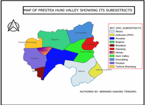
The Municipal, which covers a land size of about 1,809 sq. km, has an estimated population of 239,086 in 2023 as projected from the 2021 census. The Municipal is divided into Elleven (11) Sub-municipals for effective health care delivery.
|
FEATURE |
2019 |
|
2020 |
2021 |
2022 |
2023 |
|
Land Size |
|
1,809 Sq Km |
|
|||
|
No. Of Sub Municipals |
11 |
|
11 |
11 |
11 |
11 |
|
No. Of Health Facilities Including CHPS Zones |
58 |
|
58 |
58 |
61 |
64 |
|
Total Projected Population |
207,237 |
|
211,977 |
229,302 |
234,168 |
239,086 |
|
Expected Pregnancies (4%) |
8,289 |
|
8,479 |
9,172 |
9,368 |
9,563 |
|
WOMEN IN FERTILITY AGE (24%) |
49,737 |
|
50,874 |
55,032 |
56,200 |
57,381 |
topography
The topography of the area is generally undulating with few scarps ranging between 150m to 300m above sea level.
climate
Prestea-Huni Valley is in the Rain Forest Zone of Ghana. It enjoys a wet equatorial climate. The rainy season is usually from March to July (major season) and from September to November (minor season). The highest amount of rain is experienced in March to July and October to February as the dry season. The annual average temperatures range between 260C and 300C in the major season.
impact of human/mining Activities
Some parts of the Municipal are suffering from “environmental stress”. A number of rivers and Farmlands have been polluted and lost due to the spillage of cyanide by the mining companies. This has rendered the water, fishes and plants in these effected parts unsafe for consumption for both Man and Animal. Most affected towns are Odumasi, Damang, Kyekyewere, Akyimpim, Awudua, and Prestea among others.
religious composition
There are many religious groupings in the Municipal; these include Christians, Moslems and Traditional Believers.
Ethnicity
The Municipal is a traditional home of the Wassaws. However, because it is popular destination of migrants, several ethnic groups can be found. Two groups dominate. These are Akan and Nzema. Many northern ethnic groups form a substantial part of the population mainly for farming activities.
occupation
The major occupation of the people is mining. There are Multi-national companies engaged in the mining of gold. These companies which are mostly manned by elite whites employ Ghanaians from all over the country and other Africans. Hence, the Municipal consists of people of all calibre.
The activities of small scale illegal miners, popularly called “Galamsey” are widespread in the Municipal. The activities of these “galamsey” people poses problem to the environment since they leave pits and degrade the environmental.
Apart from mining, other activities such as agriculture, Banking, trading and others are also undertaken in the Municipal.
education
The Municipal has three Senior High schools and 73 Junior High schools. Health officers visit these schools regularly for School Health Services.
| Type/Level | Public | Private | Total |
| Primary | 110 | 99 | 209 |
| JHS | 85 | 56 | 141 |
| SHS | 3 | 0 | 3 |
| Total | 198 | 155 | 353 |
Service Availability and Access: There are Sixty-Four (64) Health care facilities in the Municipality of which Forty-Eight (48) are owned by Government, two (2) by CHAG, three (3) by Mines and Eleven (11) being privately owned.
Sub-Municipals and their population, 2023
|
SUB-DISTRICT |
% Pop |
Population |
0-11mths (4%) |
<5yrs Pop. (20%) |
Expected Pregnancy (4%) |
WIFA (24%) |
Male (49.0 %) |
Female (51.0 %) |
|
ABOSO |
10 |
23909 |
956 |
4782 |
956 |
5738 |
11715 |
12194 |
|
ASIKUMA |
5 |
11954 |
478 |
2391 |
478 |
2869 |
5857 |
6097 |
|
AWUDUA |
8 |
19127 |
765 |
3825 |
765 |
4590 |
9372 |
9755 |
|
BOGOSO |
13.5 |
32277 |
1291 |
6455 |
1291 |
7746 |
15816 |
16461 |
|
BONDAYE |
5.4 |
12911 |
516 |
2582 |
516 |
3099 |
6326 |
6585 |
|
DAMANG |
5.3 |
12672 |
507 |
2534 |
507 |
3041 |
6209 |
6463 |
|
HIMAN |
12.1 |
28929 |
1157 |
5786 |
1157 |
6943 |
14175 |
14754 |
|
HUNI VALLEY |
10.7 |
25582 |
1023 |
5116 |
1023 |
6140 |
12535 |
13047 |
|
INSUSIDING |
7.2 |
17214 |
689 |
3443 |
689 |
4131 |
8435 |
8779 |
|
PRESTEA |
16.1 |
38493 |
1540 |
7699 |
1540 |
9238 |
18862 |
19631 |
|
TARKWA BREMANG |
6.7 |
16019 |
641 |
3204 |
641 |
3845 |
7849 |
8170 |
GEOGRAPHICAL POSITIONING AND DISTRIBUTION OF HEALTH FACILITIES
Figure 1: A map showing Sub-districts in the Municipality


