District Profile
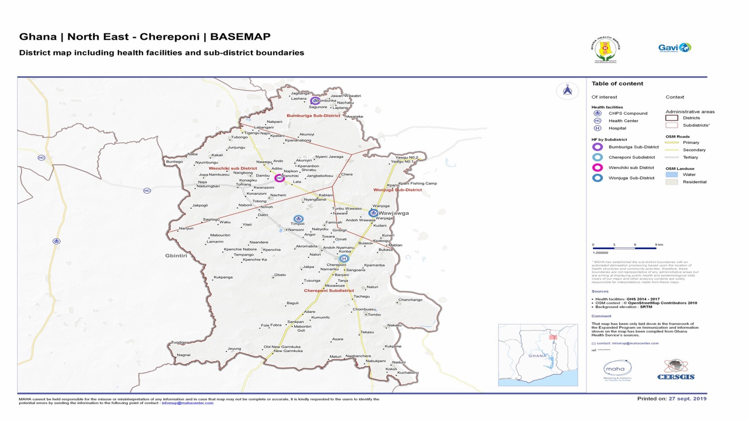
The Chereponi District is carved out of the then Saboba/ Chereponi. It is allocated in the North-Eastern corridor of Northern. Chereponi is the District Capital.
It is sandwiched between the Districts, East Mamprusi to the north, the Oti River to the East thus serving as an international boundary between Ghana and the Republic of Togo, Gushegu to the west and Saboba to the south respectively.
The district has a projected population of 96,218 (2020 population census) with 206 communities that are currently zoned into Five (5) sub-districts.
District Map
It shares boundaries with Builsa South District in the Upper East Region to the north, North Gonja District in the Savanna Region to the south, West Mamprusi Municipal to the east, Sissala East District in the Upper West Region to the west, Wa East District in Upper West Region to the northwest and Kumbungu District in the Northern Region to the south-east.
The district has an area of 2,121.31 sqkm. an estimated population of 73,169.

Climate/Environment
The district also shares boundaries with the Republic of Togo at three major entry points; Wonjuga, Tombo and Wenchiki health facilities respectively and this over burdens staff and resources for services rendered to our neighbors. The White Volta and its tributaries run through some communities in the district thus causing seasonal flooding. This makes about twenty (20) communities also inaccessible during the raining season.
Economic Activities
Agriculture is the main occupation of the people. Crops cultivated are maize, groundnuts, guinea corn, millet, beans and rice. Yam is also cultivated on small scale. These crops are produced for both consumption and cash. Cotton is a widely cultivated cash crop in the whole District. Some fishing is done on the Oti River. Main market centers are Chereponi and Wenchiki. There is also great market activity across the border where people from the district patronize Togo market.
Religion And Cultural Practices
The various ethnic groups have particular cultural practices and ways of worship, as well as traditional religions. Some cultural practices and some taboos sometimes militate against Health Service Delivery. E.g., infants tabooing needle pricks; pregnant and lactating women not permitted to eat some foods like eggs. Islam is the most predominant Religion; Christianity is of various denominations and also practiced in the districts e.g. Catholic, E.P, Assemblies of God and Pentecostals.

Ethenicity
The Anufors is the main ethnic group for the Chereponi District. A small proportion of Battor, Ewes, Moshies and Fulani’s, also exist. Various clans exist within the main ethnic groups.
Education
Education in the District is at three-(3) levels: however, ownership is Government, private, School for Life and Mission. The Government Education Institutions comprise: Day Care Centers, Primary School, Junior High School and Senior High School – Chereponi
Transports And Communications
There is public transport in the districts (MMT). Private transport is by means of mammy and cargo trucks and small buses. Motor King, Motorcycles and bicycles are also privately owned by those who can afford them. Head portage is also practiced; in caring farm produce or in going to markets.
Telecommunications are by the mobile networks such as TIGO, MTN, VODAFONE Ghana and AIRTEL Ghana are commission and providing services to the entire populace and outside. Other forms of communication are by hand and mouth massages. Mass communication is usual through public mobile van, town criers,Gongo Beating and announcements in Churches and Mosques.
Water Supply
Water supply in the district is grossly inadequate. Mechanization of pipe borne is in the pipeline for the Chereponi Township. There are however bore-holes in some communities and at health Directorate. Most parts of the districts do not have portable water. Rivers, streams and shallow ponds and the Dame serves as source of water.
Geographical Situation
The district is mainly savannah Grassland. It has one rainy season, which peaks between June – August followed by a long dry season and hamanttan
The district covers a land area of about 1,080sqkm, its 20% urban and 80 rural with over 201 settlements or villages.
Health
The Ghana Health Service is the Overseer of Health Delivery in the District. There is a District Health Management Team, which serves as the Technical and Administrative unit that supervises and co-ordinates health activities in the district. Chereponi Polyclinic has been accredited to primary Hospital- grade B
There are Five-(5) existing sub-districts and Twenty-Four-(25) Health Institutions, of which One (1) District Hospital and Seven (13) CHPS Compounds with structures and 9 without structures and Two (2) Health Centres in the District and by CHPS Policy Four (17) CHO’s making thirteen functional CHPS Zones Seventeen (22) service delivery points


