Geography And People
The Awutu Senya East Municipal (ASEM) is one of the Municipalities in the Central Region. The Municipality was carved out of the former –Awutu Senya District in 2012 and established as a Municipality by Legislative Instrument (LI) 2025. The rationale was to facilitate government’s decentralization programme and local governance system. The people of the Municipality are mainly Guans. There are other settler tribes of different ethnic backgrounds; these include the Gas, Akans, Ewes, Walas/Dagartis, Moshies, Basares and other numerous smaller tribes. The main languages spoken are Akan and English as the official language.
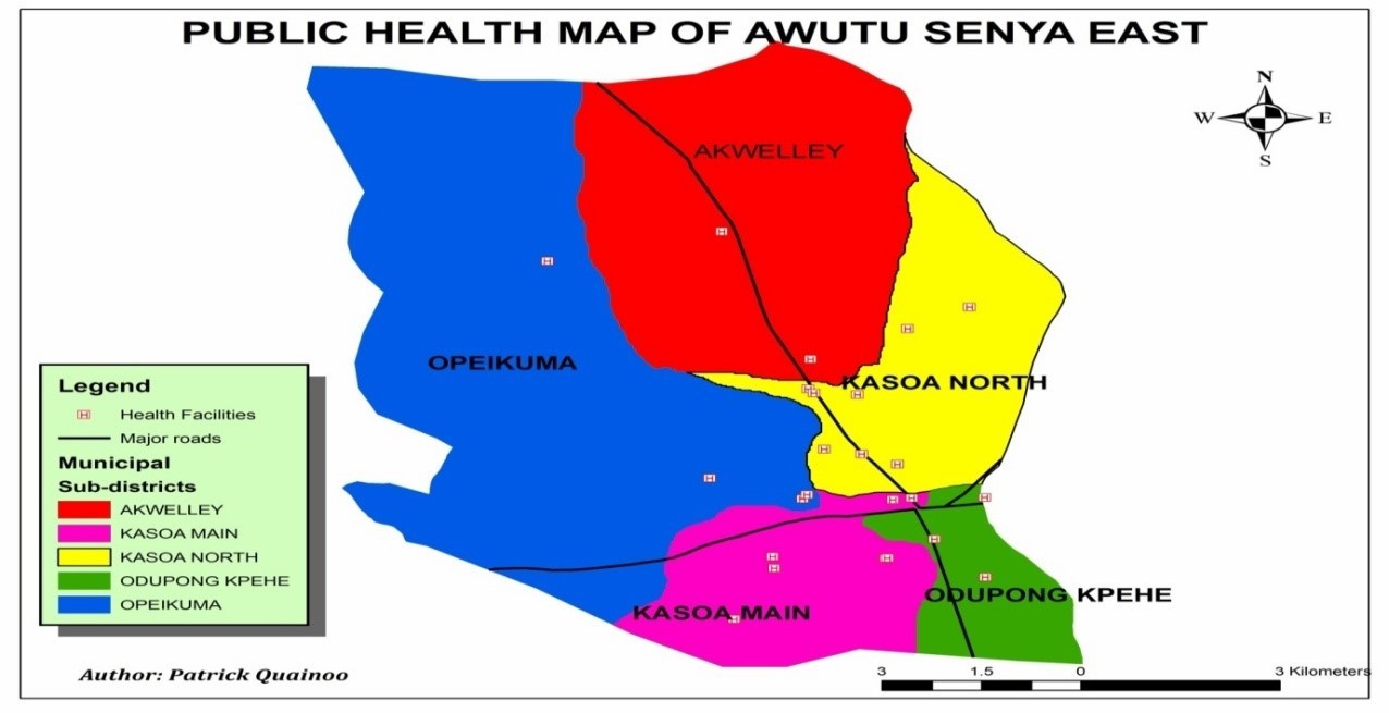
Map Of Awutu Senya By Sub-District With Facilities

Location And Size
The Awutu Senya East Municipal is located in the Eastern part of the Central Region within Latitudes 5°45 south and 6°00 North and from Longitude 0°20 west to 0°35 East. It shares common boundaries with Ga South Municipal Assembly (in the Greater Accra Region) at the East, Awutu Senya District at the North and Gomoa East District at the West and South respectively. The Municipality covers a total land area of about 180 sq km about 18% of the total area of the Central Region. Kasoa the Municipal Capital is located at the south-eastern part, about 13km from Accra, the national Capital. Other major settlements include Opeikuma, Adam Nana, Kpormertey, Ofaakor, Akweley, Walantu and Zone.
health System
The Municipality is divided into five (5) sub-districts for effective health administration; these are Akweley sub district, Kasoa North sub district, Kasoa Main sub district, Odupongkpehe sub district and Opeikuma sub district. The map below shows a summary of the sub-municipal profiles.
Demographic Characteristics
The population of the Municipality is currently estimated at 262,720 (projected from 2021 Population and Housing Census). The average annual growth rate of the Municipal is 2.4%. The ratio of male to female 1 to 1.06 and the population is basically youthful. The average Household size of the municipal is 7 (2021 PHC).
Municipal Economy
The main economic activities in the Municipal include trading- both wholesale and retail trade, agro-processing, informal sector service and commerce. Trading and its related activities are the leading economic ventures and employs about 60% of the working population in the Municipality. The private informal sector contribution is enormous. It employs about 21% of the working population in the banking and service sectors but needs to be integrated with the formal sector. Other economic activities include service (banking and internet) and agro processing (Cassava, gari and corn dough)
Type of Health Facilities
Health Services in the municipality are provided by different sectors; governmental and private health institutions. Below is a table that shows the type of health facility and numbers.
Table 3: Type of Health Facilities
| TYPE OF FACILITY | NUMBER |
|---|---|
| Government | 31 |
| Private | 36 |
| Total | 67 |
Health Context
The Municipality is divided into five (5) sub-municipalities for effective health administration. These are Akweley sub municipal, Kasoa North sub municipal, Kasoa Main sub municipal, Odupongkpehe sub municipal and Opeikuma sub municipal. The table below is a summary of the sub-municipal profiles
Health Infractracture
The health infrastructure consists of a Hospital (mother and Child Hospital), 1 Polyclinic, 3 Health centers, 26 CHPS Zones, and 30 Private Health facilities.
Key Government Sectors
The key Government sectors in the district are; the District Assembly, Ghana Health Service, Ghana Education Service, National Commission for Civic Education, Environmental Health Department, Ghana Police Service, Ghana National Fire Service, National Health Insurance Scheme.


