Assin Fosu Muncipality Profile
Assin Fosu Municipal Assembly is one of the twenty-two (22) Administrative MMDAs in the Central Region, which is located in the Northern part of the Central Region. The Municipality was created by an Act of Parliament in 2017 through theLegislative Instrument LI 2300 of 2017, following the split of the then Assin NorthMunicipal Assembly into Assin Fosu Municipal Assembly and Assin North District Assembly. The Municipality shares common boundaries with Twifo Atti Morkwa on the West, Assin South District on the South, Asikuma Odoben-Brakwa and Birim South on the East, Upper Denkyira East on the North West and Assin North District on the North. The Municipality has Assin Fosu as the capital.
Landsize
The Municipality lies within Longitudes 1 0 05’ East and 1 0 25’ West and latitudes 6 0 05’ North and 6 04’ South. It covers a land area of about 374.85 km² and comprises of about 70 settlements including Assin Foso (the Municipal Capital), Assin Nyankomasi, Assin Akropong, Assin Dompim, Wurakase, Assin Awisem, and others.
Population size, structure and composition
According to the 2021 Ghana Population and Housing Census, the 2024 estimated population of Assin Fosu Municipality is 94,740 with a growth rate of 2.4%, urban population of 55.3% and rural 44.7%. Males constitute 49.1% and females represent 50.9%.
Population Breakdown
| Sub-Districts | 2024 | 0-11 Months (4%) | 12-23 Months (4%) | 24-59 Months (10.5%) | 0-59 Months (20%) | Expected delivery (4%) | 6-59 Months (18%) | WIFA (24%) |
|---|---|---|---|---|---|---|---|---|
| Akoti | 9294 | 372 | 976 | 1859 | 1859 | 372 | 1719 | 2231 |
| Awisem | 14012 | 560 | 1471 | 2802 | 2802 | 560 | 2592 | 3363 |
| Fosu | 58350 | 2334 | 6127 | 11670 | 2334 | 2334 | 10795 | 14004 |
| Nyankomasi | 13084 | 523 | 1374 | 2617 | 523 | 523 | 2421 | 3140 |
| Muncipality | 94740 | 3790 | 3790 | 9948 | 18948 | 3790 | 17527 | 22738 |
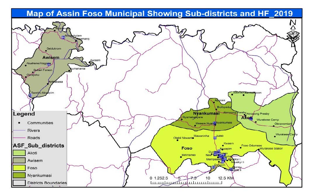
Map Of Assin Fosu Municipality

Agriculture
Although skilled agricultural, forestry, and fishery workers form 59.4% of the occupational distribution, it is also appreciated that many people in the Municipality also engage in one form of agricultural activity or other to supplement their incomes apart from the occupations they are engaged in. The 2010 Population and Housing Census reveals that a total of 14,315 of all households in the municipality, constituting 74.4 percent, engage in one form of agricultural activity or the other.
Commercial Sector
There is no clear information about the number of people employed in the sector; however, women dominate this sector with about 54% of the goods sold being industrial hardware brought from Kumasi, Takoradi and Accra and sold within and outside the Municipality
Service Sector
This sector is dominated by an educated labour force and comprises government employees, private employees, and other service workers.
Industrial Sector
Industrial activities are undertaken in small, medium and large scale, where only about 31% of industries are agro-based. Others include kente weaving, carpentry, soap making, woodcarving, saw milling, brass-made ornaments and corn milling.
Education
The Municipality currently has a total of 114 schools from basic level to tertiary level with 51 (45%) of them in the public sector whilst 63 (55%) are in the private sector as shown in the table below.
Health
Sub-districts: To improve access to health services, the Municipality has been divided into four Sub-districts namely; Awisem, Akoti, Assin Fosu and Nyankomasi sub-districts. Each of these sub-districts covers a number of communities, giving the Municipality a total of 74 communities. The sub-districts has a number of health facilities through which health care services are provided to the people in the communities.
Health Facilities
There are both government and private health institutions in the Municipality. The Municipality currently has two hospitals; St Francis Xavier Catholic Hospital, a CHAG institution at Assin Fosu and Joy Emmanuel Hospital, a private institution also at Assin Fosu. St Francis Xavier Catholic Hospital serves as the District Hospital and also caters for all referral cases from the peripheries. Aside the hospitals, there are also two (2) Health Centres, one Polyclinic, 22 CHPS Zones with 6 CHPS compounds, two clinics, and one private maternity home.
Table 3: Health Facilities And their Location
| No. | Sub-District | Facility Type | Name Of Facilities | Location |
|---|---|---|---|---|
| 1 | Fosu | Hospital | St. Francis Xavier hospital | Fosu (Newtown) |
| 2 | Fosu | Polyclinic | Fosu Polyclinic | Fosu (Effutuakwa) |
| 3 | Fosu | Hospital | Joy Emmanuel Hospital | Fosu (Pumpside) |
| 4 | Fosu | Maternity Home | Cecilia & Sammy Maternity Home | Fosu (Nsuekyi) |
| 4 | Fosu | CHPS | Trafo/Akuapim CHPS | Fosu Trafo |
| 5 | Fosu | CHPS | Dompim CHPS | Dompim |
| 6 | Fosu | CHPS | Effutuakwa CHPS | Effutuakwa/Habitat |
| 7 | Fosu | Clinic | Our Lady of Fatima Clinic | Fosu Odumasi |
| 8 | Fosu | Clinic | Dams Family Clinic | Fosu Effutuakwa |
| 9 | Nyankumasi | CHPS | Nyankumasi CHPS Compound | Nyankumasi (Habitat) |
| 10 | Nyankumasi | CHPS | Juaso CHPS Compound | Juaso |
| 11 | Akropong | Health Centre | Akoti Health Centre | Akropong/Wurakese |
| 12 | Awisem | Health Centre | Awisem Health Centre | Awisem |
| 13 | Awisem | CHPS | Akwanhyiam CHPS | Akwanhyiam |


